


SailTimer™ app for iPhone and iPad
Developer: SailTimer Inc.
First release : 09 Sep 2009
App size: 61.13 Mb
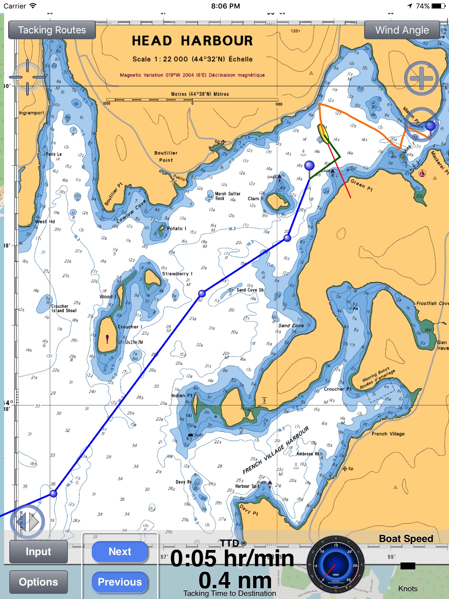
Display your optimal tacks on a chart, and the exact distance and time on each tack. Standard GPS chartplotters do not account for tacking distances. But if they do not know the distance you will travel, how can they calculate your correct ETA? SailTimer gives you a quick and easy display of your optimal tacks and TTD™ (Tacking Time to Destination).
Whether for cruising or racing, it is important to be able to determine the best heading on all points of sail. Sailing off the wind increases boat speed but lengthens the distance. Heading too far upwind shortens the distance but reduces speed. To help you select the best heading, SailTimer continuously updates your optimal tacks.
Operating Instructions and Unique Features:
• Save waypoints on the map. Rename them. Then easily display the optimal tacks, tacking distances, headings and times to get to a waypoint.
• Use our wireless Wind Instrument (www.SailTimerWind.com) to see wind direction, angle & speed. Just enter a waypoint and your optimal tacks will update automatically as the wind changes.
• Worldwide vector charts: If you have the Navionics Boating app, you can also use the same charts here with a yearly subscription. Navionics terms of use: SailTimerApp.com/vectorcharts.html. Payment will be charged to iTunes Account at confirmation of purchase. Subscription automatically renews unless auto-renew is turned off in iTunes Account Settings at least 24-hours before the end of the current period. Account will be charged for renewal within 24-hours prior to the end of the current period, with the same cost for renewing the subscription again.
• Marine charts (raster) based on the paper charts are also available as low-cost in-app purchases for USA, US Virgin Islands, Puerto Rico, large-scale charts of The Bahamas and Cuba, and New Zealand. Aerial photos and road maps worldwide are available free. All can be used offline.
• The white crosshair icon in the top left is the “Follow-Me” button. If clicked, it turns blue and keeps your location in the center of the screen as you move. Unselect when not moving to look around the map, and when you want to zoom in and out.
• If using a Wind Instrument, you can enlarge the Wind Speedometer to keep an eye on wind gusts. Click the Graph button and you can save or share a graph showing your boat speed and wind speed. The graph saves these for up to 24 hours as long as the device is not rebooted.
• Audio Navigation: when using the wireless Wind Instrument, optionally hear wind conditions or boat speed when they change by more than a set amount. It is like having a tactician in the cockpit with you. You can put your iPhone/iPad away safe and dry, and use a Bluetooth speaker or earbuds. Keep your hands and eyes free for sailing — no screen required. You can even shut off the screen to reduce heat and power consumption, and continue to hear audio reports.
• Your device will not go to sleep when the app is open, to allow you to continue to monitor your progress on the chart. You can also continue to track your tacking results with the app running in the background or when the device is asleep (unless you hard-quit).
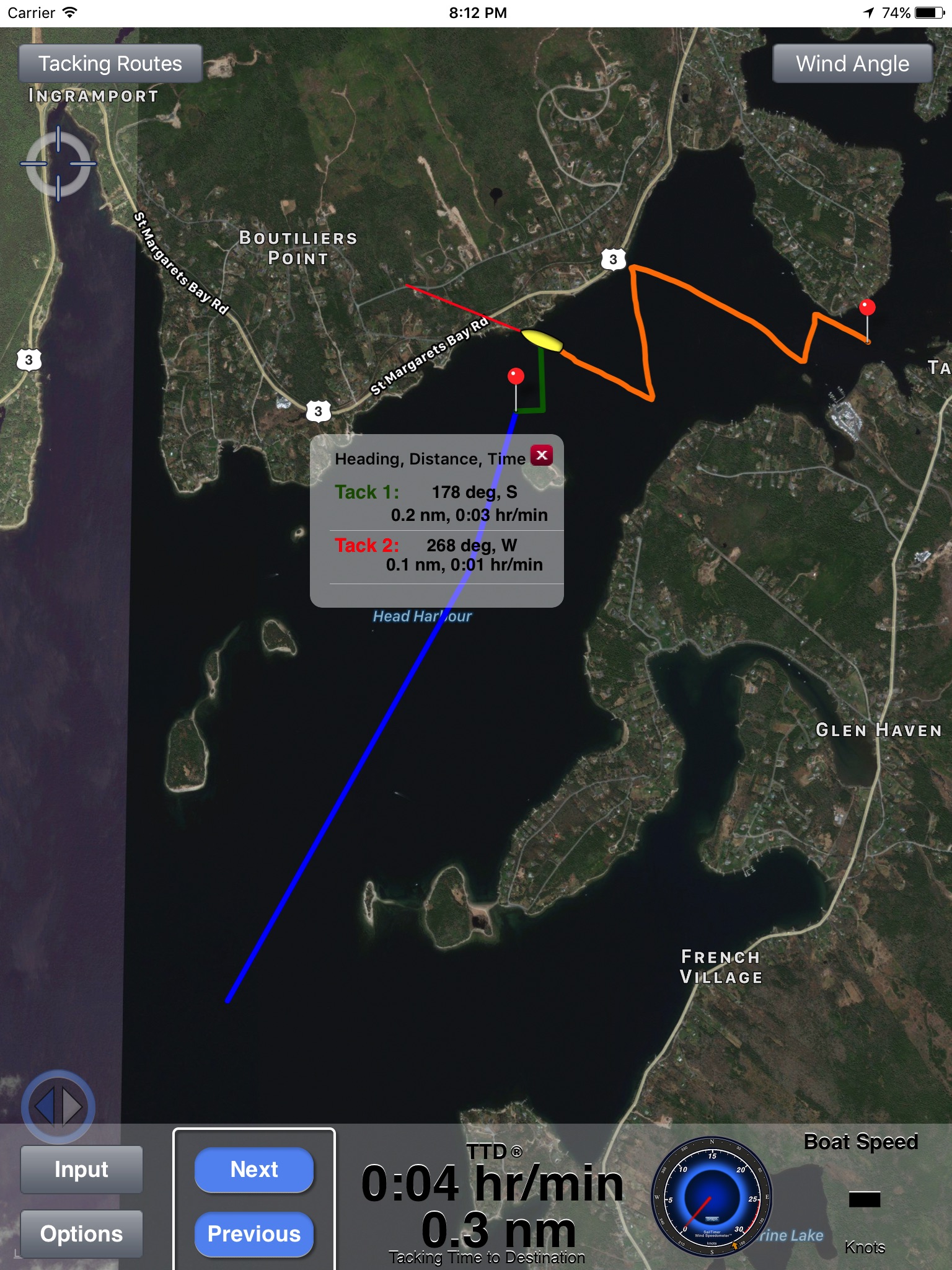
• Click on the pin at the end of a pair of tacks to see the distances, heading and time on each tack.
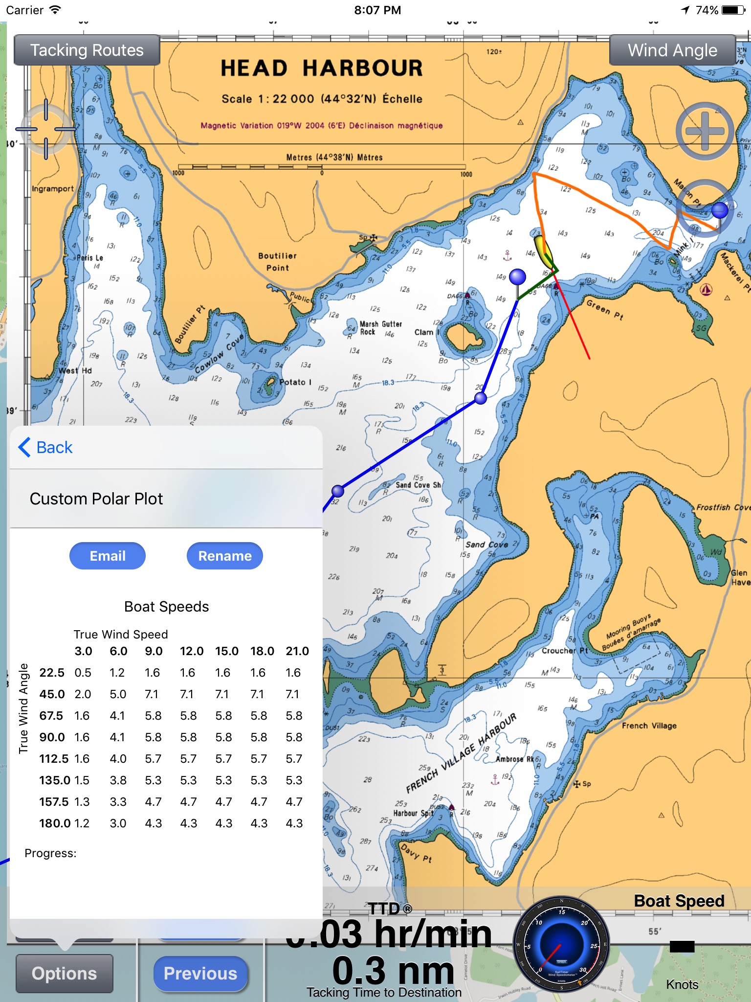
• Custom polar plots: The app can learn your unique sailboats speed profile on all points of sail, for the most accurate tacking results.
• Switch to the port or starboard tack to avoid obstructions, or let the app automatically display the tack nearest to your current heading.
• Save, import or email your GPS track.
• Convert from Apparent to True wind speed & direction.
Continued use of GPS running in the background can dramatically decrease battery life. This app may use your location even when it isn’t open, which can decrease device battery life.
Latest reviews of SailTimer™ app for iPhone and iPad
Is to be clear on the actual limitations: only for USA AND CANADA Cant even simulate any marine route without map in Europe. Shouldnt be for sale on appleStore Europe
Hi, This latest version is still incredibly poor, at least when using the Canadian charts. Its slow, the charts tiles load sporadically, and unless you are really careful with your zoom level, they will disappear at the most in opportune time. I really want this app to work but I just dont trust it, so I still use Navionics for anchoring.
You get basic app, every option you click on requires additional purchase, I wasted my money!
Rubbish on the ipod touch. Until they allow the current position to be set manually (ie without GPS) it is functionally useless.
This is a neat idea and would be very helpful if the application would actually work. Be aware that being able to use NOAA charts or Active Captain requires additional in-app purchases, which bring the total cost of the app to over $30.-. Still, map download does not work properly. It takes forever to download even small maps, and then they do not stich together properly. The application is also extremely(!) slow and hangs very often, requiring it to be shut down completely and re-started. Absolutely not yet ready for prime time.